

Previous Section Headers
3.5.1.3 Latitude Data Records
Following the header records in each time sample are the latitude data
records. All words in a latitude data record are 8-byte floating point numbers
written out
in the native machine representation. So on the Cray the values will be written
out as 8-byte Cray floating point numbers while on a SGI workstation, for
example, they will be written out at 8-byte IEEE floating point numbers. When the
model is multitasked the latitude records are written in a random order.
This occurs because writing of the latitude data records into a sequential
access disk file occurs from within a multitasked loop over latitudes (in
linemsbc). So a given latitude is written when the processor that
calculates that latitude is finished.
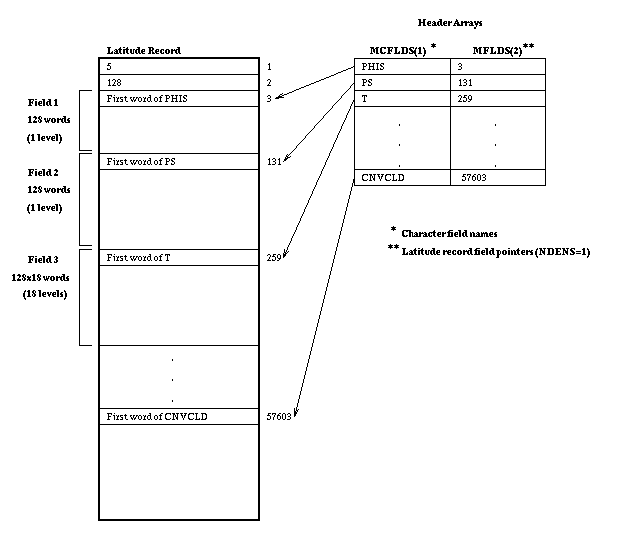
Figure 3.8 illustrates
a typical latitude record of a time sample within a history file. In this
figure, latitude record number 5 (the fifth latitude from the southern-most)
is depicted for T42 horizontal resolution. This figure also shows how the
pointers in MFLDS relate to the field data contained in the record,
along with the variable names in mcflds.
Figure 3.8. A Typical history file latitude
record.
Showing unpacked data, and its relationship to the pointers in MFLDS
and variable names in MCFLDS.

A few important items to notice about the latitude data record are listed
below:
-
The first word of the record is an index into the latitude array in the
real header record, identifying the latitude associated with this data.
This field is required due to the random ordering of the latitude data
records within a time sample.
-
The second word of the record is a count of the number of longitudes contained
in that record. Currently, this number is always float(plon)
(the latitude record contains only floating point values) but allows for
the possible future implementation of a variable number of longitude grid
points along each latitude line.
-
Field information starts in word 3 of the record. The pointers contained
in the header array MFLDS point to the beginning word of data
for each field, packed or unpacked. Thus, it is possible to read in a packed
record and unpack only the desired fields.
-
All fields in a latitude record correspond to a single latitude index.
If a field is single level, then it contains grid-point data at plon
longitude points, for the given latitude index. If a field is multi-level,
then it contains grid-point data at (plon x plev) points,
for the given latitude index.


 Search page
Questions on these pages can be sent to...
erik@ucar.edu .
$Name: ccm3_6_6_latest2 $ $Revision: 1.36.2.1 $ $Date: 1999/03/25 21:38:46 $ $Author: erik $
 Search page


