|
Documentation Community Datasets | ||
| Phase 2 Transient Dynamics |
|
|||||||||||||||
|
|
![]() User's
Guide
User's
Guide
![]() Dataset
Description:
Dataset
Description:
Overview
Historical Climate
Climate Change Scenarios
References
Animations
![]() File
Format
File
Format
![]() Data
Portal
Data
Portal
![]() Data
Use Policy
Data
Use Policy
![]() Dataset
Citation
Dataset
Citation
- Canadian Centre for Climate Modeling and Analysis (model = CGCM1)
- Hadley Centre for Climate Prediction and Research, UK (model = HADCM2)
Historical Climate Series (TCLIMATE)
The first objective for VEMAP Phase 2 dataset development was the creation of a ~100-year gridded monthly and daily time series of climate for the conterminous United States that included realistic interannual variability. This effort was in collaboration with the NSF Geophysical Statistics Project at NCAR. Development of the dataset is reported in Kittel et al. (1997).
As in the VEMAP1 database,
the historical dataset has: (1) daily and monthly versions, (2) physical consistency
among variables on a daily basis, (3) consistency between climate and topography,
and (4) needed input variables for VEMAP2 models (minimum and maximum temperature,
precipitation, vapor pressure, and solar radiation).
Key steps in the development of the gridded, multivariate, monthly and daily historical dataset were:
(1) Input monthly datasets. Monthly mean minimum and maximum temperature (Tmo) and monthly precipitation (PPTmo) historical time series were derived from:
(a) NCDC's Historical Climate Network (HCN) monthly data from 1895 (~1200 stations)
(b) Shorter period (e.g., 1951-1990) cooperative network monthly station data (for an additional ~6000-8000 stations)
(c) SNOTEL site data
This merged input dataset provides a high density of stations
and adequate-to-excellent spatial sampling of climate throughout most of the
conterminous U.S., including at higher elevations (primarily from the SNOTEL
sites).
(2) Serially-complete records. We created serially-complete 99-year
monthly min/max Tmo and PPTmo records for climate stations
from Step(1) using a local (moving-window) kriging model, following Haas
(1990, 1995) (Kittel et al. 1997). The model imputes monthly climate anomalies
where station records are discontinuous or limited in length.
(3) Spatial interpolation with topographic adjustment. The
serially complete station data were then passed to Chris Daly (Oregon State
University) for spatial interpolation with topographic adjustment. Min/max temperature
and precipitation station data were spatially interpolated to the 0.5deg. lat/long
VEMAP grid for each month in the 99-yr record using a newly expanded version
of PRISM (Daly et al., in review; 2001; Daly and Johnson 1999). PRISM incorporates
elevation, aspect, and other topographic information to grid temperature and
precipitation data. Daly was funded for this task by USDA Forest Service Global
Change Research Program.
(4) Daily temperature and precipitation generation. We generated daily min/max temperature and precipitation using a modified version of Richardson's (1981, Richardson and Wright 1984) stochastic weather generator WGEN. The version was provided by Sue Ferguson (USFS) and incorporated modifications from Rick Katz and Linda Mearns (NCAR). We further modified the code to permit separate parameterizations for wet vs. dry periods in the record (following the work of Dan Wilks).
We parameterized the model based on HCN and coop network daily station data and ran it for the VEMAP grid for the 99-yr record. The daily values were constrained by gridded monthly T and PPT data from step (3), so that the daily and monthly versions of the historical dataset represent the same climate.
As part of our quality checking process, we compared daily statistics
from the gridded, generated product and station data. We found that daily frequency
distributions and extremes match well for a range of climates across the domain.
(5) Estimation of solar radiation and humidity. We implemented a new version of MTCLIM (version 3; Thornton and Running 1999, Thornton et al. 2000) for VEMAP2 to create daily (and monthly) vapor pressure (VP), daytime relative humidity, total incident solar radiation (SR), and irradiance (IRR) from daily T and PPT. This version of MTCLIM includes improved estimation of radiation and humidity, as developed by Peter Thornton, Steve Running, John Kimball, and Rob Kremer (U. of Montana) (Kimball et al. 1997, Thornton and Running 1999, Thornton et al. 2000).
Generated vapor pressure fields compare well with the Marks (1990) VP climatology and simulated SR with NCDC/NREL SAMSON data.
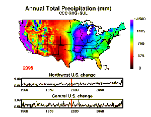
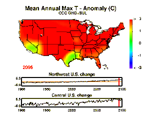
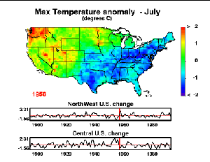
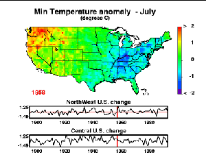
For VEMAP2, our second major objective is to develop transient climate change scenarios based on coupled atmosphere-ocean general circulation model (AOGCM) transient climate experiments. The purpose of these scenarios is to reflect time-dependent changes in surface climate from AOGCMs in terms of both (1) long-term trends and (2) changes in multiyear (3-5 yr) to decadal variability patterns, such as ENSO.
We have processed scenarios from transient greenhouse gas experiments
with sulfate aerosols from the Canadian
Climate Center (CCC) and the Hadley Centre (HADCM2; Mitchell et al. 1995,
Johns et al. 1997); accessed via the Climate
Impacts LINK Project, Climatic Research Unit, University of East Anglia.
Daly, C., and G.L. Johnson. 1999. PRISM spatial climate layers: their development and use. Short Course on Topics in Applied Climatology, 79th Annual Meeting of the American Meteorological Society, 10-15 January, Dallas, TX. 49 pp. http://www.ocs.orst.edu/prism/prisguid.pdf.
Daly, C., W.P. Gibson, G.H. Taylor, GL Johnson, and P. Pasteris. In review. Towards a knowledge-based approach to the statistical mapping of climate. Climate Research.
Daly, C., G.H. Taylor, W. P. Gibson, T.W. Parzybok, G. L. Johnson, P. Pasteris. 2001. High-quality spatial climate data sets for the United States and beyond. Transactions of the American Society of Agricultural Engineers 43: 1957-1962.
Haas, T.C. 1990. Lognormal and moving window methods of estimating acid deposition. J. Amer. Stat. Assoc. 85:643-652.
Haas, T.C. 1995. Local prediction of a spatio-temporal process with an application to wet sulfate deposition. J. Amer. Stat. Assoc. 90:1189-1199.
Johns, T.C., R.E. Carnell, J.F. Crossley, J.M. Gregory, J.F.B. Mitchell, C.A. Senior, S.F.B. Tett, and R.A. Wood. 1997. The second Hadley Centre coupled ocean-atmosphere GCM: Model description, spinup and validation. Climate Dynamics 13:103-134.
Kimball, J.S., S.W. Running, and R. Nemani. 1997. An improved method for estimating surface humidity from daily minimum temperature. Agricultural and Forest Meteorology. 85:87-98.
Kittel, T.G.F., J.A. Royle, C. Daly, N.A. Rosenbloom, W.P. Gibson, H.H. Fisher, D.S. Schimel, L.M. Berliner, and VEMAP2 Participants. 1997. A gridded historical (1895-1993) bioclimate dataset for the conterminous United States. Pages 219-222, in: Proceedings of the 10th Conference on Applied Climatology, 20-24 October 1997, Reno, NV. American Meteorological Society, Boston.
Marks, D. 1990. The sensitivity of potential evapotranspiration to climate change over the continental United States. Pages IV-1 - IV-31 in: Biospheric feedbacks to climate change: The sensitivity of regional trace gas emissions, evapotranspiration, and energy balance to vegetation redistribution. Gucinski, H., D. Marks, and D.P. Turner, (eds.) EPA/600/3-90/078. U.S. Environmental Protection Agency, Corvallis, OR.
Mitchell J.F.B., T.C. Johns, J.M. Gregory, and S. Tett. 1995. Climate response to increasing levels of greenhouse gases and sulphate aerosols. Nature. 376:501-504.
Richardson, C.W. 1981. Stochastic simulation of daily precipitation, temperature and solar radiation. Water Resources Research 17:182-190.
Richardson, C.W., and D.A. Wright. 1984. WGEN: A Model for Generating Daily Weather Variables. U.S. Department of Agriculture, Agricultural Research Service, ARS-8, p 83.
Thornton, P.E., and S.W. Running. 1999. An improved algorithm for estimating incident daily solar radiation from measurements of temperature, humidity, and precipitation. Agricultural and Forest Meteorology, 93:211-228.
Thornton, P.E., H. Hasenauer, and M.A. White. 2000. Simultaneous estimation of daily solar radiation and humidity from observed temperature and precipitation: an application over complex terrain in Austria. Agricultural and Forest Meteorology, 104:255-271.
|
|
|
|
Updated Sunday, 10-Feb-2002 12:58:09 MST
|